Posted Date: December 05, 2025 | Case No: 59-RG/2025 | Department: Board of Revenue, Punjab (Provincial Disaster Management Department/PDMA)
🗺️ Geographic Information Systems Specialist in Disaster Management
The Punjab Public Service Commission (PPSC) announces opportunities for Assistant GIS positions under the Board of Revenue, Punjab (Provincial Disaster Management Department/PDMA) through Advertisement No. 46/2025. This 3-year contract position in BS-16 scale seeks GIS and Space Science graduates to contribute to spatial data management and disaster mapping across Punjab. This technical role offers geographic information specialists a chance to apply their skills in critical government operations.
Educational Qualification Requirements
Mandatory Academic Qualification
- Degree Program: BS (Hons) – 4 Years Bachelor’s Honors Program
- Specialization Options:
- Geographic Information System (GIS)
- Space Sciences
- Division Requirement: Second Division mandatory
- University Recognition: HEC recognized university
Specific Field Requirements
- GIS Programs: BS GIS, Geomatics, Geoinformatics
- Space Sciences: Astronomy, Astrophysics, Space Technology
- Related Fields: Remote Sensing, Cartography, Surveying
- Note: General Geography degrees not specified – must be GIS or Space Sciences specific
Preferred Technical Competencies
- GIS Software: ArcGIS, QGIS, ERDAS Imagine
- Remote Sensing: Image processing, analysis
- Database Management: Spatial databases
- Programming: Python for GIS, SQL
- Mapping Tools: Cartographic design, map production
👥 Demographic & Eligibility Criteria
Age Specifications
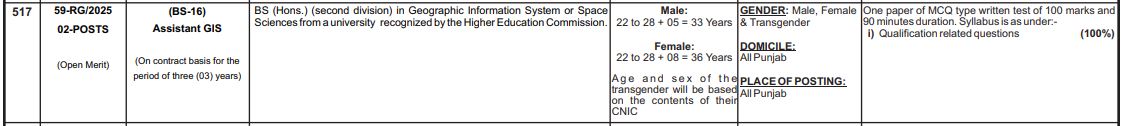
- Male Candidates: 22 to 28 years + 5 years = Maximum 33 years
- Female Candidates: 22 to 28 years + 8 years = Maximum 36 years
- Transgender Candidates: Age as per CNIC
- Calculation Date: Age as of December 22, 2025
Geographical Requirements
- Domicile: All Punjab (Any district eligible)
- Posting Location: All Punjab (Provincial Disaster Management Department)
- Transfer Policy: May be posted anywhere in Punjab
- Gender Policy: Equal opportunity for all genders
- Quota Status: Open Merit only (2 positions)
📝 Application Procedure: Comprehensive Guide
Phase 1: Online Application Submission
- Portal Access: Official PPSC website: www.ppsc.gop.pk
- Account Management: Register or use existing account
- Position Selection: “Assistant GIS” – Case No. 59-RG/2025
- Form Completion: Enter GIS/Space Sciences education details
- Document Upload: Scan and upload BS (Hons) degree and transcripts
Phase 2: Application Fee Payment
- Available Payment Methods:
- ATM networks nationwide
- Internet Banking platforms
- Mobile Banking applications
- 1Link member bank branches
- Digital payment solutions: JazzCash, EasyPaisa, U Paisa
- Receipt Preservation: Essential for documentation
Phase 3: Mandatory Hard Copy Submission
- Submission Deadline: Within 7 working days after December 22, 2025
- Required Document Package:
- Signed printout of online application
- Two complete sets of attested documents
- BS (Hons) degree in GIS/Space Sciences
- Complete transcripts/mark sheets
- HEC recognition certificate
- Punjab domicile certificate
- CNIC copy
- Fee payment proof
- Matric certificate (age proof)
- Recent passport photographs
- Critical: Incomplete submission = Automatic disqualification
📑 Essential Documentation Checklist
Academic Documents
- Primary Degree:
- BS (Hons) degree certificate in GIS/Space Sciences
- Complete 8-semester mark sheets
- University recognition proof
- Second division percentage certificate
- Previous Education:
- Matric certificate (age verification)
- Intermediate certificate
- Any additional relevant certifications
Technical Portfolios (If Available)
- GIS Projects Portfolio:
- Sample maps and spatial analyses
- Project reports
- Software certifications
- Research publications
Personal Documents
- Administrative Documents:
- CNIC copy (front and back)
- Domicile certificate (Punjab)
- Recent passport photographs (4)
- Application fee payment receipt
✍️ Written Examination Details
Test Structure & Format
- Examination Type: One paper MCQ type written test
- Test Duration: 90 minutes
- Total Marks: 100 marks
- Question Format: Multiple Choice Questions (MCQs)
Syllabus Breakdown – 100% GIS & Space Sciences
Section A: Geographic Information Systems (50-60%)
- GIS Fundamentals
- GIS concepts and components
- Spatial data models (vector/raster)
- Coordinate systems and projections
- Data quality and accuracy
- Spatial Analysis
- Overlay operations
- Buffer analysis
- Network analysis
- Surface analysis and interpolation
- GIS Applications
- Urban and regional planning
- Environmental management
- Disaster risk assessment
- Resource management
Section B: Remote Sensing & Cartography (30-40%)
- Remote Sensing Principles
- Electromagnetic spectrum
- Sensor systems and platforms
- Image interpretation and classification
- Digital image processing
- Cartography & Mapping
- Map design principles
- Symbolization and generalization
- Thematic mapping
- Web mapping technologies
Section C: Space Sciences (10-20%)
- Space Science Fundamentals
- Celestial mechanics
- Planetary science
- Space weather
- Satellite technology
- GPS & Navigation
- Global Positioning System principles
- GPS data collection
- Differential GPS
- Navigation applications
🏢 About PDMA’s GIS Operations
Departmental GIS Functions
- Disaster Mapping: Risk assessment and hazard mapping
- Resource Management: Spatial inventory of resources
- Emergency Response: Real-time mapping for disaster response
- Planning Support: Spatial data for disaster preparedness
Technical Environment
- Software Used: Government standard GIS software
- Data Sources: Satellite imagery, survey data, field data
- Collaboration: Inter-departmental spatial data sharing
- Innovation: Implementation of new geospatial technologies
⏰ Important Dates & Deadlines
| Activity | Date/Deadline |
|---|---|
| Advertisement Published | December 05, 2025 |
| Online Application Opens | Immediately |
| Online Application Closes | December 22, 2025 |
| Hard Copy Submission | Within 7 days after Dec 22, 2025 |
| Written Test Date | PPSC website announcement |
| Interview Schedule | For shortlisted candidates |
❓ Frequently Asked Questions
Q1: Can BS Geography graduates apply?
A: Only if their degree specifically includes GIS or Space Sciences specialization. General Geography degrees may not qualify unless they have GIS concentration.
Q2: Is experience with specific GIS software required?
A: While not explicitly required, proficiency in standard GIS software (ArcGIS, QGIS) would be beneficial for the role.
Q3: What is the career progression for this position?
A: Contract positions can lead to extensions and potentially permanent positions based on performance and departmental needs.
Q4: Are there field work requirements?
A: The position may involve both office-based GIS work and field data collection as required by disaster management operations.
📞 Official Contact Information
- PPSC Official Website: www.ppsc.gop.pk
- Department Contact: Provincial Disaster Management Department, Punjab
- Technical Support: PPSC website help resources
- Office Location: Board of Revenue, Punjab
SEO Keywords: PPSC GIS Jobs 2025, Assistant GIS BS-16, Government GIS Positions Punjab, Geographic Information System Jobs, PPSC Advertisement 46/2025, Disaster Management GIS Careers, Spatial Analyst Recruitment, BS GIS Graduates Jobs, Remote Sensing Positions, Cartography Jobs Government, PDMA Technical Jobs, Geospatial Analysis Careers.
⚠️ Critical Application Information:
- Specific Degree: BS (Hons) in GIS or Space Sciences only
- Division Requirement: Second Division mandatory
- Posting Flexibility: Anywhere in Punjab
- Contract Duration: 3-year initial contract